Vancouver, B.C. – HM Exploration Corp. (“HM Exploration” or the “Company”) (CSE: HM) is pleased to present the results of its Phase One exploration program at the Company’s Devil’s Den Project (the “Project”) located west of Port Alberni, British Columbia.
“We have finished processing our data collected from the Phase One program at the Devil’s Den Project.” said the Company’s Director & CEO Nicholas Rodway. “The newly acquired data has produced high resouloution magnetic coverage over the project as well as the first ever lithogeochemical map of the Project. This new data will be invaluable for further evaluating the potenal at Devils Den. We look forward to providing further updates as we get closer to the 2025 summer field season.”
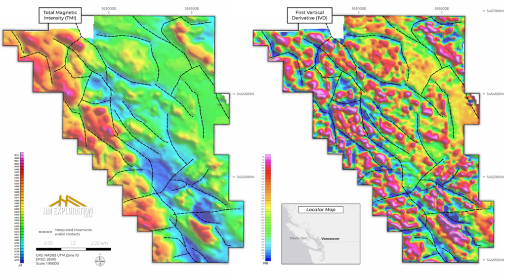
Results of UAV Magnetic Survey
The results from a high-resolution unmanned aerial vehicle (UAV) magnetic survey recently completed by the Company has defined several high-priority follow-up targets. These targets were further reinforced by integrating results from recent prospecting and lithogeochemical surveys conducted by the Company. Of particular note, there are two zones that exhibit structural complexity, hydrothermal alteration, and elevated copper, zinc, and nickel geochemistry. Additionally, the high-resolution UAV survey identified a series of previously unrecognized northwest-southeast trending structures. The figures below show the geophysical results with the structural/lineament interpretation superimposed on both maps.
Lithogeochemical Survey
The existing geological map covering the project area was published by the British Columbia Geological Survey in 2017 as Open File 2017-08 (Cui et al., 2017). This map provides a generalized geological framework characterized primarily by two lithological units, which inadequately represent the area’s true geological complexity. According to this previous interpretation, a north-northwest trending lithological boundary divides the property, separating volcanic rocks of the Upper Triassic Karmutsen Formation in the east from granodioritic and quartz dioritic intrusive rocks of the Jurassic Island Plutonic Suite to the west.
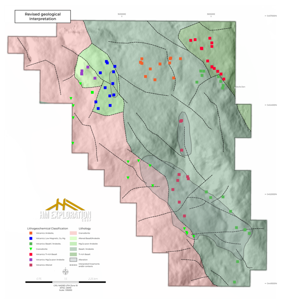
Historical geological work and field observations within the project area and regionally have indicated substantial lithological variability within the Karmutsen volcanic sequence. To address this, the company initiated a comprehensive lithogeochemical survey aimed at generating a property-scale geochemical dataset to better characterize and delineate the volcanic units within the Karmutsen Formation. The updated geological interpretation and lithogeochemical sampling locations are presented in Figure 2.
Integration of lithogeochemical data with results from a magnetic survey has highlighted distinct geochemical variations within the volcanic sequences, providing valuable insights for future exploration targeting. Key outcomes from this integrated analysis are as follows:
- The westernmost lithological unit, previously mapped as the granodiorite-quartz diorite complex of the Island Plutonic Suite, exhibits only subtle geochemical distinctions from adjacent volcanic units. This minor differentiation is interpreted to result from the evolved (relatively felsic) nature of the volcanic units in proximity to the intrusion. Field observations and detailed lithological descriptions were instrumental in refining the geological contact in the property’s southern section.
- A unit located in the northwest part of the survey area, originally identified as granodioritic intrusive rocks, has been reassigned to the Karmutsen Formation based on field evidence and lithogeochemical data. While typical Karmutsen volcanic rocks are enriched in magnesium, lithogeochemical analyses from this region revealed anomalous depletion in magnesium and calcium. In combination with field observations of silicification and oxidation, these geochemical signatures suggest moderate hydrothermal alteration has occurred. Magnetic survey data corroborate this interpretation, highlighting this region as a magnetic low, consistent with magnetite destruction during alteration.
- The northeastern section is characterized by geochemically distinct primitive basaltic rocks, enriched in Fe, Ti, V, Cr, and Mg. This geochemical signature indicates a relatively less differentiated, Fe-Ti-rich tholeiitic basalt flow, corresponding spatially to a magnetic high in the geophysical survey.
- Although a regional north-south trending fault is indicated in previous geological mapping, high-resolution magnetic data does not support the presence of a major fault structure in this orientation. Instead, the survey area exhibits a series of northwest-southeast trending linear magnetic features interpreted as smaller-scale, potentially late-stage fault systems. Subtle geochemical differences are also observed, distinguishing chromium-enriched basaltic units from andesitic rocks toward the west.
This refined geological interpretation provides an enhanced framework to guide future exploration activities on the property.
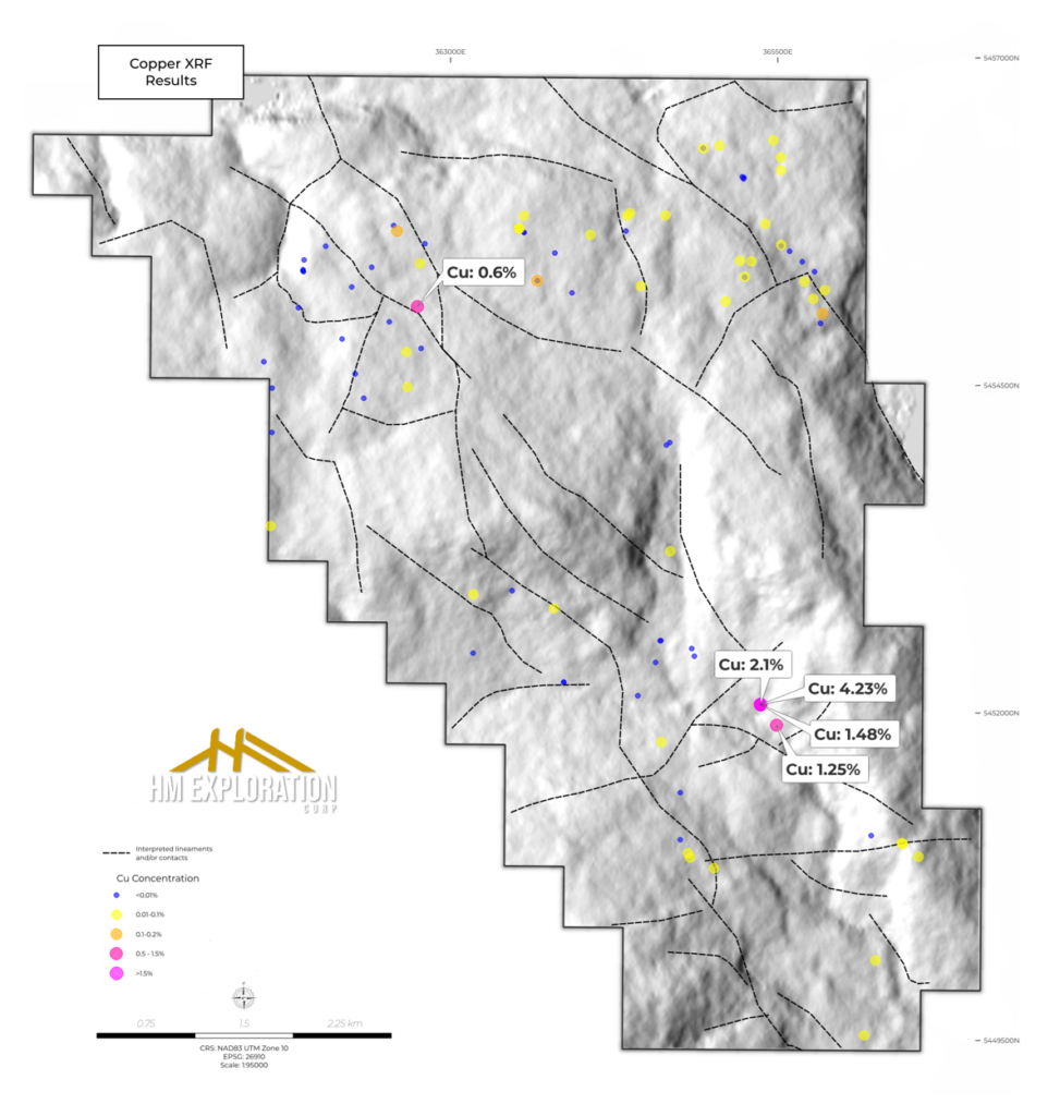
Two mineralised zones were identified in the field and subsequently analysed using pXRF. In the northern part of the property, a roadside outcrop exhibited copper oxide staining and returned elevated copper values of up to 0.6% Cu. This occurrence corresponds to the historically documented MINFILE “West Dauntless” showing and aligns with a northwest-trending structural feature identified in the geophysical interpretation. In the southwest portion of the property, a second outcrop hosting malachite mineralisation was identified. This location coincides with the MINFILE occurrence “J.F”, and pXRF analyses returned copper values of up to 4.3% Cu. Similar to the Dauntless West showing, this mineralisation is also associated with a northwest-trending structural lineament highlighted by the geophysical survey. The company’s current working hypothesis suggests that northwest-trending structural features exert a stronger control on mineralisation than previously recognised. Consequently, these structural orientations will be the focus of targeted investigation in future exploration programs.
About the Phase One Program
The Phase One exploration program (the “Program”) consisted of the collection of 355 line-kilometers of high-resolution unmanned airborne vehicle (UAV) geophysical magnetic data, prospecting of historical copper and gold showings, and a property-wide litho-geochemical mapping study consisting of 101 Portable X-Ray Floresence readings. The UAV airborne geophysical survey was flown at a line spacing of 50 to 100 meters using a drone-deployed high-sensitivity potassium magnetometer. The sensor height was maintained at 60 meters above the terrain using advanced terrain-following flight software. This approach leveraged modern UAV technology to acquire high-resolution magnetic data in a time- and cost-efficient manner. The flight plan was executed to cover historical and recently discovered high-grade copper mineralization, as well as areas with limited historical exploration. The high-resolution data is currently being processed, and the results will be used to better define faults and structures that are presumed to act as fluid corridors for the mineralization observed at the surface.
References
Cui, Y., Miller, D., Schiarizza, P., and Diakow, L.J., 2017. British Columbia digital geology. British Columbia Ministry of Energy, Mines and Petroleum Resources, British Columbia Geological Survey Open File 2017-8, 9p. Data version 2019-12-19.
MINFILE: West Dauntless – https://minfile.gov.bc.ca/Summary.aspx?minfilno=092F++703
MINFILE: J.F – https://minfile.gov.bc.ca/Summary.aspx?minfilno=092F++617
NATIONAL INSTRUMENT 43-101 DISCLOSURE
Nicholas Rodway, P.Geo, (EGBC Licence# 46541) (Permit to Practice# 100359) is CEO and Director of the Company, and a qualified person as defined by National Instrument 43-101 – Standards of Disclosure for Mineral Projects. Mr. Rodway has reviewed and approved the technical content in this release.
ABOUT HM EXPLORATION CORP.
HM Exploration Corp. (HM) is a Canadian mineral exploration company focused on the acquisition and development of mineral projects in Canada. The Company is currently advancing the Devil’s Den Project, an exploration-stage exploration project that consists of two contiguous claims totaling approximately 3,200 hectares, located on Vancouver Island, British Columbia. The Company conducted an exploration program on the project in 2022, and four geochemical grids were established to identify possible buried mineralization in areas of possible anomalous gold, copper, and other minerals. Multiple high grade mineral occurrences were uncovered including Cu values of up to 4.68% at surface (Devil’s Den NI 43-101, Nov 2022). The Project hosts multiple historical adits with high-grade surface occurrences that remain undrilled. HM Exploration believes that there has been a lack of adequate modern exploration techniques applied to the Project in the past and this presents the opportunity for significant new discoveries.
On Behalf of the Board of Directors
HM EXPLORATION CORP.
“Nicholas Rodway”
CEO & Director
+1 (604) 681-1568
info@hmexploration.com
FORWARD LOOKING STATEMENTS
Certain statements in this news release are forward-looking statements, including with respect to future plans, and other matters. Forward-looking statements consist of statements that are not purely historical, including any statements regarding beliefs, plans, expectations or intentions regarding the future. Such information can generally be identified by the use of forwarding-looking wording such as “may”, “expect”, “estimate”, “anticipate”, “intend”, “believe” and “continue” or the negative thereof or similar variations. The reader is cautioned that assumptions used in the preparation of any forward-looking information may prove to be incorrect. Events or circumstances may cause actual results to differ materially from those predicted, as a result of numerous known and unknown risks, uncertainties, and other factors, many of which are beyond the control of the Company, including but not limited to, business, economic and capital market conditions, the ability to manage operating expenses, dependence on key personnel, that certain exploration methods, including the Company’s proposed exploration model for the Project, may be ineffective or inadequate in the circumstances, that competitive, governmental, geopolitical, environmental and technological factors may affect the Company’s operations and markets, that the Company’s specific plans and timing thereof may change, that the Company may not have access to or be able to develop any minerals because of cost factors, type of terrain, or availability of equipment and technology, and that the Company may not be able to raise sufficient funds to carry out or complete its plans. Forward looking statements in this news release include, but are not limited to, statements respecting: the Project and its mineralization potential; the results of the Program; the Company’s objectives, goals, or future plans with respect to the Project; further exploration work on the Project in the future. Such statements and information are based on numerous assumptions regarding present and future business strategies and the environment in which the Company will operate in the future, anticipated costs, and the ability to achieve goals. Factors that could cause the actual results to differ materially from those in forward-looking statements include, the continued availability of capital and financing, litigation, failure of counterparties to perform their contractual obligations, loss of key employees and consultants, and general economic, market or business conditions. Forward-looking statements contained in this news release are expressly qualified by this cautionary statement. The reader is cautioned not to place undue reliance on any forward-looking information.
The Canadian Securities Exchange (CSE) does not accept responsibility for the adequacy or accuracy of this release.