Devil's Den Project
Overview
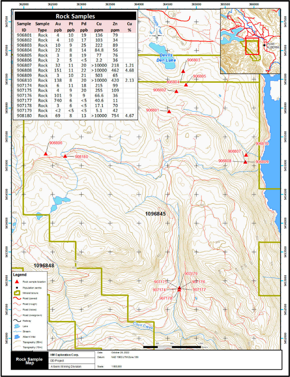
HM Exploration conducted an exploration program on the Devil’s Den Project which consisted of the collection of 412 soil samples, 22 silt samples, and 17 rock grab samples
-
There are multiple historical adits on the project and high-grade surface occurrences that remain undrilled
-
A previously conducted detailed 1,661-line km magnetic, electromagnetic, and radiometric airborne geophysical program over the project identified several targets that were not properly evaluated and warrant follow-up work.
-
Lack of adequate modern exploration techniques applied to the project presents the opportunity for significant new discoveries.
Regional Geology
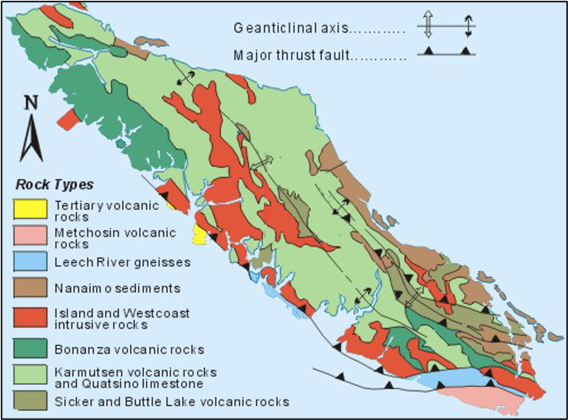
Southern Vancouver Island is underexplored and known to have a rich geological setting
Vancouver Island consists of three tectonic terranes: the Wrangellia, Pacific Rim, and Crescent. Wrangellia covers the northern 90% of the island, which also extends to the coastal mainland and the Queen Charlotte Islands.
The Pacific Rim and Crescent terranes each cover about 5% of the south end of Vancouver Island and are thought to represent exotic tectonic plates, which collided with and became attached to Vancouver Island.
The rocks that make up Vancouver Island range in age from Paleozoic to Pliocene and represent three major volcano-sedimentary events (Paleozoic, Triassic and Jurassic), one major sedimentary event (Cretaceous) and four major intrusive events (Triassic, Jurassic, Eocene and Miocene/Pliocene).
Port Alberni is located in Wrangellia, in south-central Vancouver Island and is surrounded by some of the most varied and structurally complex geology on the island. Port Alberni also sits between two major uplifts exposing the island’s oldest Paleozoic volcano-sedimentary rocks of the Sicker and Buttle Lake Groups, the Cowichan Uplift to the southeast and the Myra Falls Uplift to the northwest.
Devil's Den: Exploration History
Cruikshank Explorations Ltd.
Completed an I.P. ground geophysical survey along the western side of the Alberni Inlet covering old excavations containing copper mineralization in several MINFILE showings
1962
1988
Napier Explorations Inc.
Conducted geological mapping and geochemical sampling on the northeast part of the property covering the MINFILE occurrences Holk 092F155 and Devils Den 092F551. Soil sampling identified two copper-zinc+/-gold anomalies, and rock samples from quartz-sulphide veins yielded up to 4.15 g/t Au from the Holk, and 1.7% Cu from Dauntless (Stritychuk Hopkins, J.M. and Leriche, P.D.)
1989
Brockton Resources Inc.
Conducted geological mapping, grid layout, claim staking, soil sampling, trench blasting, and VLF- EM and magnetometer geophysics over the northeastern quadrant of the Property. The combined soil sampling and geophysics highlighted nine possible targets on the property, most corresponding to anomalous gold or copper soil values or coincident mag-VLF-EM liniments.
2005 - 2006
SYMC Resources Ltd.
Contracted Fugro Airborne Surveys Corp. who flew a detailed 1,661-line km. magnetic, electromagnetic and radiometric airborne geophysical pro.gram over the Property in September 2005. Several targets were identified.
Nahminto Resources Inc.
Engaged Auracle Geospatial Science Inc. in 2012, who completed a remote sensing analysis including hyper spectral analysis, mineral alteration mapping, and fused radar data analyses over the Property.